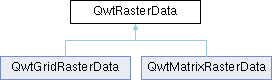
QwtRasterData defines an interface to any type of raster data. 更多...
#include <qwt_raster_data.h>
类 | |
| class | ContourPlane |
| class | PrivateData |
Public 类型 | |
| enum | Attribute { WithoutGaps = 0x01 } |
| Raster data attributes 更多... | |
| enum | ConrecFlag { IgnoreAllVerticesOnLevel = 0x01 , IgnoreOutOfRange = 0x02 } |
| Flags to modify the contour algorithm 更多... | |
| using | ContourLines = QMap< double, QPolygonF > |
| Contour lines | |
Public 成员函数 | |
| QwtRasterData () | |
| Constructor | |
| virtual | ~QwtRasterData () |
| Destructor | |
| void | setAttribute (Attribute, bool on=true) |
| Set an attribute | |
| bool | testAttribute (Attribute) const |
| Test an attribute | |
| virtual QwtInterval | interval (Qt::Axis) const =0 |
| virtual QRectF | pixelHint (const QRectF &) const |
| Return a hint for the raster item, about how to align the pixels | |
| virtual void | initRaster (const QRectF &, const QSize &raster) |
| Initialize the raster | |
| virtual void | discardRaster () |
| Discard the raster | |
| virtual double | value (double x, double y) const =0 |
| virtual ContourLines | contourLines (const QRectF &rect, const QSize &raster, const QList< double > &levels, ConrecFlags) const |
| Calculate contour lines | |
详细描述
QwtRasterData defines an interface to any type of raster data.
QwtRasterData is an abstract interface, that is used by QwtPlotRasterItem to find the values at the pixels of its raster.
Gaps inside the bounding rectangle of the data can be indicated by NaN values ( when WithoutGaps is disabled ).
Often a raster item is used to display values from a matrix. Then the derived raster data class needs to implement some sort of resampling, that maps the raster of the matrix into the requested raster of the raster item ( depending on resolution and scales of the canvas ).
QwtMatrixRasterData implements raster data, that returns values from a given 2D matrix.
成员枚举类型说明
◆ Attribute
Raster data attributes
Additional information that is used to improve processing of the data.
| 枚举值 | |
|---|---|
| WithoutGaps | The bounding rectangle of the data is spanned by the interval(Qt::XAxis) and interval(Qt::YAxis). WithoutGaps indicates, that the data has no gaps ( unknown values ) in this area and the result of value() does not need to be checked for NaN values. Enabling this flag will have an positive effect on the performance of rendering a QwtPlotSpectrogram. The default setting is false.
|
◆ ConrecFlag
构造及析构函数说明
◆ QwtRasterData()
| QwtRasterData::QwtRasterData | ( | ) |
成员函数说明
◆ contourLines()
|
virtual |
Calculate contour lines
An adaption of CONREC, a simple contouring algorithm. http://local.wasp.uwa.edu.au/~pbourke/papers/conrec/
- 参数
-
[in] rect Bounding rectangle for the contour lines [in] raster Number of data pixels of the raster data [in] levels List of limits, where to insert contour lines [in] flags Flags to customize the contouring algorithm
- 返回
- Calculated contour lines
◆ discardRaster()
|
virtual |
Discard the raster
Discard a raster
After the composition of an image QwtPlotSpectrogram calls discardRaster().
     The default implementation does nothing, but if data has been loaded
     in initRaster(), it could be deleted now.
- 参见
- initRaster(), value()
◆ initRaster()
|
virtual |
Initialize the raster
Initialize a raster
Before the composition of an image QwtPlotSpectrogram calls initRaster(), announcing the area and its resolution that will be requested.
The default implementation does nothing, but for data sets that are stored in files, it might be good idea to reimplement initRaster(), where the data is resampled and loaded into memory.
- 参数
-
[in] area Area of the raster [in] raster Number of horizontal and vertical pixels
- 参见
- discardRaster(), value()
◆ interval()
|
pure virtual |
在 QwtGridRasterData , 以及 QwtMatrixRasterData 内被实现.
◆ pixelHint()
|
virtual |
Return a hint for the raster item, about how to align the pixels
Pixel hint
pixelHint() returns the geometry of a pixel, that can be used to calculate the resolution and alignment of the plot item, that is representing the data.
Width and height of the hint need to be the horizontal and vertical distances between 2 neighbored points. The center of the hint has to be the position of any point ( it doesn't matter which one ).
An empty hint indicates, that there are values for any detail level.
Limiting the resolution of the image might significantly improve the performance and heavily reduce the amount of memory when rendering a QImage from the raster data.
The default implementation returns an empty rectangle recommending to render in target device ( f.e. screen ) resolution.
- 参数
-
[in] area In most implementations the resolution of the data doesn't depend on the requested area.
- 返回
- Bounding rectangle of a pixel
被 QwtGridRasterData , 以及 QwtMatrixRasterData 重载.
◆ setAttribute()
| void QwtRasterData::setAttribute | ( | Attribute | attribute, |
| bool | on = true |
||
| ) |
Set an attribute
Specify an attribute of the data
- 参数
-
[in] attribute Attribute to set [in] on On/Off state
◆ testAttribute()
| bool QwtRasterData::testAttribute | ( | Attribute | attribute | ) | const |
Test an attribute
Test if an attribute is enabled
- 参数
-
[in] attribute Attribute to test
- 返回
- True when attribute is enabled
◆ value()
|
pure virtual |
在 QwtGridRasterData , 以及 QwtMatrixRasterData 内被实现.
该类的文档由以下文件生成:
- /home/runner/work/QWT/QWT/src/core/qwt_raster_data.h
- /home/runner/work/QWT/QWT/src/core/qwt_raster_data.cpp